An exploration · systems
Ringing the Peaks
Seeing the shape beneath the map
These explorations weave memory and present thinking — not records of what happened, but attempts to learn by holding the past and the present in the same frame. Why it reads this way →
Personal opening to write: the natural doorway is King's Cross, 1987 — meeting Bill Hillier on the London Regeneration Consortium project, the unit at UCL Bartlett, and the idea of King's Cross as a 'black hole' in the urban fabric, a rift torn by the industrial concentration of rail and canal. That severance is the same force this essay describes at national scale. You've worked with Space Syntax since 1987, before they spun out of UCL — which is why the map below is an old companion, not a found object. One short first-person paragraph in the Thread voice: 'I have noticed something. Let me show you.'
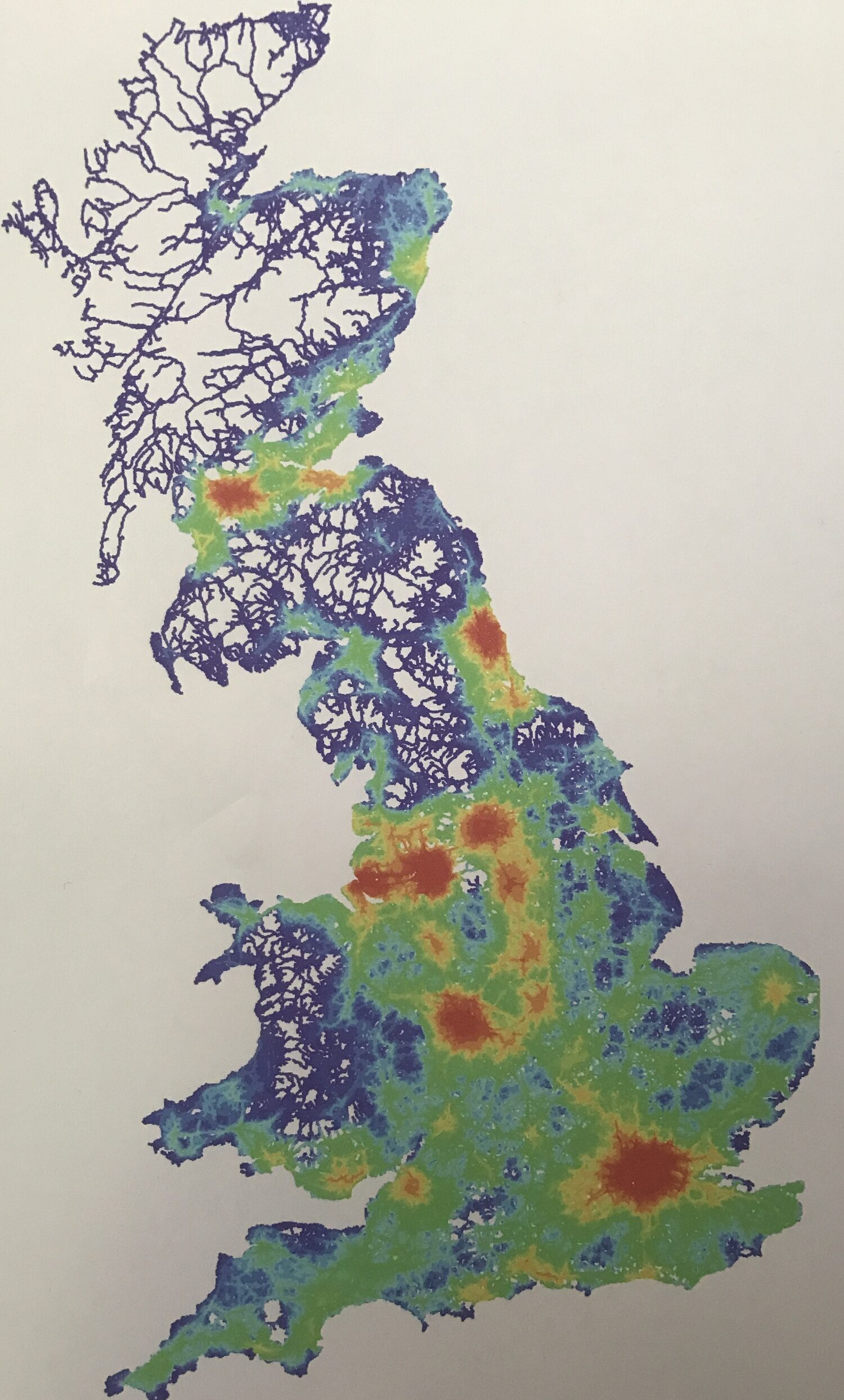
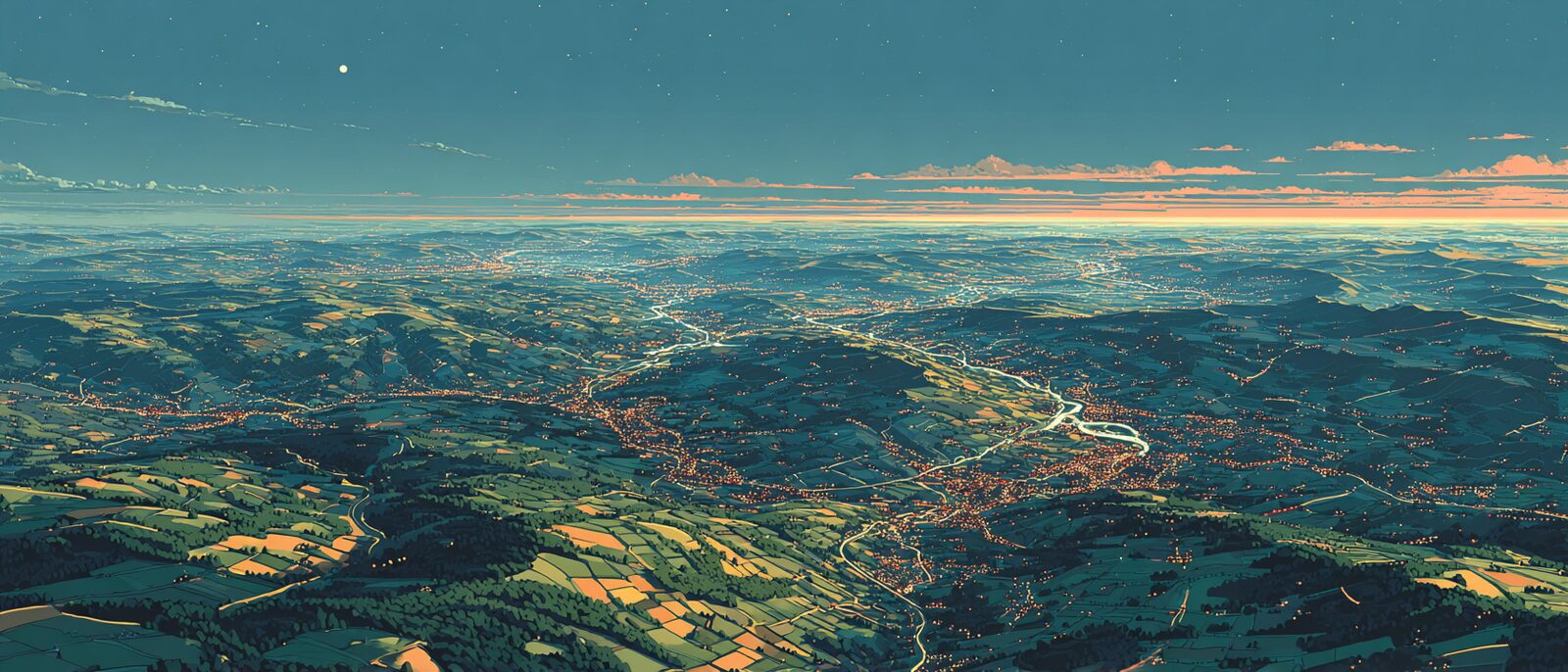
London dominates. The South East glows brightly. The Highlands fade into the periphery. Nothing unexpected.
Then the eye begins to wander north. And something remarkable emerges.
Manchester. Liverpool. Leeds. Sheffield. Derby. Nottingham. Stoke. Leicester. Birmingham. Individually they are understood as separate places. Collectively they form one of the most connected landscapes in Europe.
The map does not reveal where people live. It reveals how places relate. And once seen, a question becomes difficult to ignore.
What if Britain has been looking at the North through the wrong lens?
The first network

The story begins long before railways. Long before canals. Long before industrialisation. It begins with the Romans.
When the Romans arrived in Britain they did not encounter a nation. They encountered tribes, kingdoms, regional identities, different systems of power and governance. Their challenge was not transport. It was integration. How do disparate territories become a coherent whole?
The answer was infrastructure. Roads allowed soldiers to move, officials to travel, messages to circulate, taxes to be collected, authority to be projected. The Roman road network was not built because people wished to travel. It was built because Rome wished to govern.
Infrastructure was statecraft made visible.
What followed is perhaps the most important lesson in British history. The roads endured. Settlements clustered around them. Trade followed them. New generations built upon them. Again and again Britain inherited the network created by those who came before. The skeleton remained even as the flesh changed.
Geography writes the next chapter
The next great layer was shaped not by empire but by landscape. Rivers became corridors of movement. The Severn. The Trent. The Humber. The Mersey. The Thames. The easiest route through the landscape became the preferred route through the economy.
When canals arrived during the Industrial Revolution they largely followed the same logic. Engineers worked with contours, watersheds and valleys. The result was not a planned national network. It was a practical one — a network shaped by geography itself. The easiest route often became the permanent route.
And permanence matters, because every investment that follows reinforces what came before.
Infrastructure has memory.
The industrial explosion
Then came the event that transformed Britain more profoundly than any period before or since. Industrialisation. Coal. Iron. Steel. Textiles. Manufacturing. Global trade. The great industrial centres emerged rapidly, but not uniformly.
Manchester developed around concentrated industries, mills and large-scale production. Liverpool grew through maritime trade, docks and global exchange. Sheffield specialised in steel. The Black Country in metalworking. Leeds in textiles and commerce.
Birmingham followed a different path. It became known as the city of a thousand trades. Rather than a handful of dominant industries it supported thousands of interconnected specialisms — workshops, toolmakers, engineers, craft manufacturers, suppliers. An industrial ecosystem rather than an industrial machine.
This difference matters because it shaped identity. Manchester feels different from Birmingham. Liverpool feels different from Sheffield. Yet this difference can obscure a deeper truth.
Different expressions of the same industrial revolution. Different responses to geography, to resources, to opportunity. Historically they were not competitors. They were codependent. The steelworks depended on the ports. The ports depended on manufacturing. Manufacturing depended on coal. Coal depended on transport. Transport depended on engineering.
Each place specialised. The network prospered. The whole became greater than the sum of its parts.
The railway nation
The railways accelerated this process beyond anything previously imaginable. For the first time people moved at industrial scale. Goods had always travelled. Now people travelled too. Workers, students, merchants, inventors. Ideas. Knowledge. Opportunity itself became mobile.
The railways did not merely connect places. They transformed what places could become.
Yet the network emerged quickly and chaotically. Competing companies raced to establish routes. Parallel lines appeared. Redundancies emerged. Duplication was common. The objective was not elegance. It was growth. The resulting network was messy but extraordinarily connected — a system optimised for possibility.
Forgetting the system
The twentieth century brought a different philosophy. Efficiency replaced expansion. Routes were judged individually. Passenger numbers. Operating costs. Revenue. Utilisation.
The Beeching cuts became the clearest expression of this thinking. The question was simple. Does this line justify itself? Rarely was a deeper question asked. What role does this line play within the wider system?
A branch line may have appeared marginal. Yet it could strengthen an entire network — provide resilience, enable alternative routes, support future growth, connect otherwise separate economic regions.
The system disappeared beneath the spreadsheet.
Britain stopped seeing networks and started seeing links.
The administrative illusion
At the same time another distortion emerged. Administrative boundaries became mistaken for reality. The Midlands became separate from the North. The North West became separate from Yorkshire. Economic geography became fragmented into political geography.
The categories became so familiar that they began to shape our thinking. Manchester belongs to the North. Birmingham belongs to the Midlands. Leeds belongs to Yorkshire. Nottingham belongs to the East Midlands.
These labels are useful for administration. But networks do not recognise them. Supply chains ignore them. Labour markets ignore them. Innovation systems ignore them. Economic relationships ignore them.
The map reveals this immediately. The red zone surrounding the Peak District does not stop at a regional boundary. It simply follows connectivity. The network sees something the administrative map cannot.
Ringing the peaks
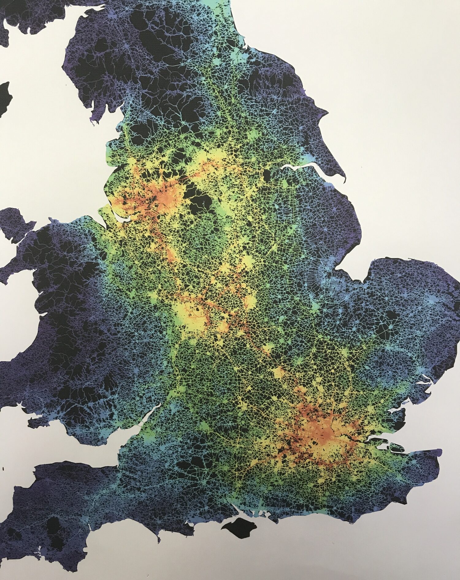
This brings us back to the question posed by the image. Why is the strongest concentration of connectivity outside London arranged around the Peak District?
The conventional answer focuses on crossing the Pennines. Connecting east to west. Manchester to Leeds. Liverpool to Hull. A line across a barrier. Yet the map suggests something larger. The value may not lie primarily in crossing the mountains. It may lie in strengthening the ring around them.
A distributed urban system already exists. The people are there. The universities are there. The industries are there. The airports are there. The research institutions are there. The logistics networks are there. The relationships are already there. What is missing is recognition.
The Peak District is not the obstacle. It is the centre.
Around it sits a network that has been forming for two thousand years. Roman roads established the skeleton. Waterways reinforced it. Canals intensified it. Railways accelerated it. Motorways expanded it. Industrialisation gave it purpose. Yet we continue to view it through administrative fragments rather than systemic relationships.
From seeing to doing
Action turn to write (this is the beat London and Letting the Water Back both have and this piece is currently missing): if the ring already exists, what changes? Funding judged at network scale, not line by line — the opposite of Beeching. Governance drawn around the real economic geography rather than inherited county lines. The Peak District managed as a shared centre, not a void between authorities. Keep it to a few lines: move the reader from recognising the system to acting on it.
The view from above
Perhaps the lesson is not about railways at all. Nor roads. Nor infrastructure. It is about perception.
Every generation inherits a network built by those who came before. Most see only the individual links. A few glimpse the whole. The Romans understood that infrastructure was a means of creating a coherent system from disparate territories. Industrial Britain understood that prosperity emerged from connection. The map suggests we may have forgotten both lessons.
We debate lines. We debate stations. We debate journey times. Meanwhile the deeper structure sits quietly beneath our feet.
The red ring around the Peak District is not a proposal. It is not a vision. It is not an aspiration. It is something that already exists. A hidden geography. A network civilisation. A pattern visible only when we stop looking at cities and start looking at relationships.
Once seen, it becomes difficult not to ask whether the future of the North lies not in connecting places across the Pennines, but in recognising the system that has been ringing the peaks all along.